
Myponga
Enjoy, explore, preserve Myponga Reservoir Reserve
Works are currently underway at Myponga Reservoir Reserve, to enhance recreational activities.
Advice on any changes to visitor access during these works will be shared on this page.
Visit our Water Talks website for more information on the project.
Nestled near the township of Myponga on the stunning Fleurieu Peninsula, about an hour’s drive south of Adelaide, is the Myponga Reservoir Reserve. The trail here is ideal for walking and running with room for families to enjoy a picnic. You can also head to the lookout to take in the scenic surrounds. Head out on the water for a paddle in your canoe or kayak and explore the 250 hectares of water. Shore-based fishing is available within the publicly-accessible area of the reserve, or you can drop a line in from your canoe or kayak.

At a glance
 Open 7.30am - 5pm (standard time), 7.30am - 8pm (daylight saving time). Closed on Total Fire Ban Days and for operational activity (gates will be closed).
 Accessible car park
 Fishing - permit required
 Walking/running
 Cycling
 Picnicking
 Lookout
 Wildlife and birdwatching
 Accessible kayaking/canoeing
 Automated External Defibrillator
 No dogs (assistance animals allowed)
Activities and facilities
To prepare for your visit, please check the conditions of access.
Fishing
With a fishing permit, you can drop a line in the from the shoreline in the reserve's public area or on the water from a canoe or kayak.
Due to lower than usual water levels, some parts of the shoreline may be steep and slippery or have deep sucking mud. Please take care when fishing from these areas.
Walking/running/hiking
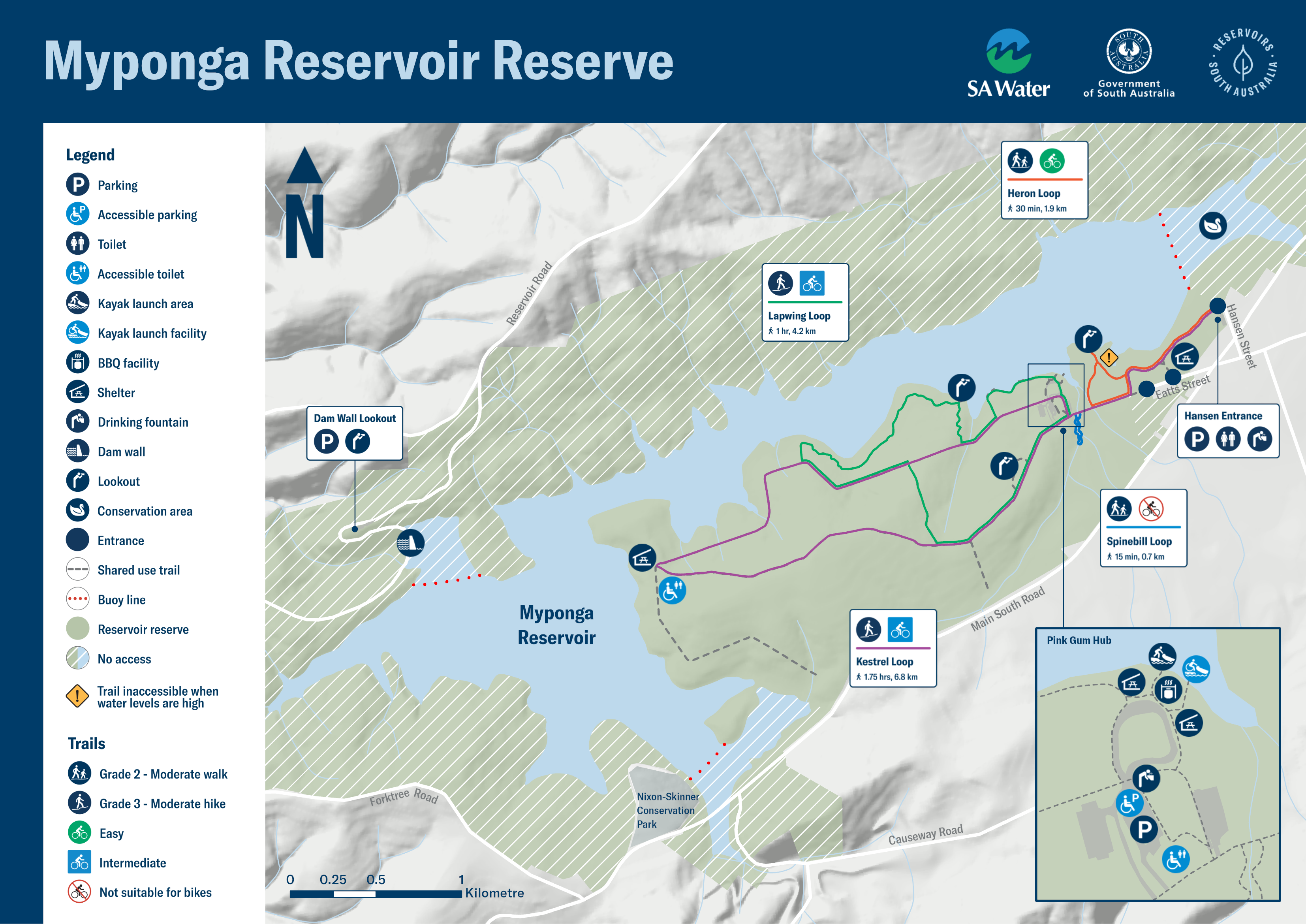
Explore Myponga’s 10.5km of unsealed trails, suitable for walking, running and hiking.
The 3.3km south-eastern loop track takes you through open plains, forested areas and native vegetation. The easy, unsealed trail is suitable for families with children, and for walking and running.
The 3km western loop is a Grade 3 trail, suitable for people with moderate fitness levels, and bushwalking experience is recommended as it has short steep sections and uneven surfaces.

Navigate the reserve with the free Avenza app
Download the Myponga Reservoir Reserve map
Cycling/mountain biking
Myponga offers mountain bike experiences for people of all ages with varying skill levels. Beginners should head to the south-eastern side of the reservoir reserve, while the western trails offer downhill thrills and challenging hills for more experienced riders.
The unsealed trail network at Myponga is shared by both cyclists and walkers. Please be considerate of other trail users.
Navigate the reserve with the free Avenza app
Download the Myponga Reservoir Reserve map
 Kayaking/canoeing
Choose your experience with a kayak or canoe, from a short meander to a full day's kayaking adventure exploring the 250 hectares of water surrounded by stunning landscapes. There is an all-accessibility kayak facility located at Pink Gum Hub. The facility is approximately 180m from the carpark. Please note, there is no storage for wheelchairs on or near the launch facility.
During the warmer months when the reservoir's level can be low, bring a trolley to get your kayak or canoe to the water's edge more easily.
Our accessible kayak launch facilities at the Myponga reservoir are temporarily unavailable for use.
Kayaking is still permitted, but please take care when launching from the shoreline as some areas may be steep and slippery or have deep sucking mud.
We’ll provide further updates when these facilities reopen.
The accessible kayak launch facility at the Happy Valley Reservoir remains open for use.
Picnicking
There are several picnic tables along the trail and of course you’re welcome to pack a picnic basket complete with a blanket or chairs so you can sit back, relax and enjoy the view.
Lookout
The lookout above the Myponga dam wall on the western side of the reservoir is the prime stop for a stunning view of the reservoir, the dam wall and its spillway. When the reservoir levels are low enough, you can follow the Heron Loop out to a deck lookout at the water’s edge.
Wildlife and birdwatching
Take some time and see if you can spot some of the special species that call Myponga home. More than 120 bird species live in the area including some that enjoy life by the water and others that can be found inland. Myponga Reservoir is home to an abundance of kangaroos. You can also watch for native animals, lizards and listen for frogs. Please keep your distance from wildlife: do not feed, disturb, or remove native flora and fauna.
![]() With the exception of assistance animals, dogs are not welcome at reservoir reserves as they can carry harmful organisms that can easily contaminate the water and present a risk to the safety of the drinking water. Dogs also pose a threat to local native birds and wildlife.
With the exception of assistance animals, dogs are not welcome at reservoir reserves as they can carry harmful organisms that can easily contaminate the water and present a risk to the safety of the drinking water. Dogs also pose a threat to local native birds and wildlife.
Free offline maps
Use the free Avenza app to navigate around the reservoir reserve, record your GPS tracks or enjoy other features. Download the map to your mobile device and you can access it even without mobile coverage.
Download the Myponga Avenza map here.
Click map below for a print-friendly version.
Maps on your mobile
If you have a smartphone or tablet you can download the free Avenza Map app and have interactive reservoir reserve maps on hand when you need them.
The app uses your device’s built-in GPS to plot your real-time location within the reserve onto a map. The app can be used without a network connection and without roaming charges. You can also measure area and distance, plot photos and drop placemark pins.
How to get it working on your device:
1. Download the Avenza Maps app from the app store (iOS/Android) whilst you are still in range (its free!).
2. Open up the app and click the shopping cart icon.
3. Click ‘Find’ and type the name of the reservoir reserve you are looking for.
4. Click on the map you are after and install it (all our maps are free).
5. You will now find a list of your installed maps on the home page of the Avenza Maps app.
6. Use our maps through the Avenza Mapa app while in the reserve and never take a wrong turn again.
What sets Myponga Reservoir apart
Capacity: 27.6 gigalitres (there are one billion litres in a gigalitre), that’s enough to fill more than 55 Adelaide Ovals with water
Built: 1958-1962
Myponga Reservoir was built at a time of rapid economic expansion in South Australia. This reservoir, along with the raising of the Mount Bold Dam wall (also completed in 1962) increased the state’s storage capacity by 10 million gallons (45.46 million litres) supporting population growth and the expansion of industry in Adelaide’s south.
The idea of constructing a dam at Myponga River was investigated as early as 1930, but plans were delayed in favour of building Mount Bold Dam first.
In planning the project, a model was constructed in the hydraulics lab at the Adelaide University to determine the best design of the spillway to manage flood conditions.
The construction camp included:
- three permanent buildings
- six weatherboard buildings to house 12 single working men
- a recreation room
- a mess room
- a bathroom and laundry building
- an administration building
- three garages.
Apart from the three permanent buildings, the others were dismantled and removed once the reservoir was built.
You can check current reservoir levels at SA Water's website.
Myponga Reservoir mystery
Two roads lie under the reservoir: the original Myponga Yankalilla main road and the Lovely Valley road. New roads were constructed to replace these, one taking you across the reservoir to the south of Myponga, and the other taking you across the dam wall on the western side of the reservoir. Also under the water is the site of the Lovely Valley School which was open from 1865 until 1869.
Water quality
Myponga Reservoir is one of 16 across the state that help supply water to more than 1.7 million South Australians.
Water from the reservoir is treated at the Myponga Water Treatment Plant before it is supplied to customers living on the Fleurieu Peninsula.
Treating drinking water before it’s supplied to homes, businesses, schools, hospitals and more, is important to make sure it is clean and safe to drink straight from the tap. You can learn how SA Water treats water and maintains the quality its customers value and rely upon.
At a glance
- Open 7.30am - 5pm (standard time), 7.30am - 8pm (daylight saving time). Closed on Total Fire Ban Days and for operational activity (gates will be closed).
- Accessible car park
- Fishing - permit required
- Walking/running
- Cycling
- Picnicking
- Lookout
- Wildlife and birdwatching
- Accessible kayaking/canoeing
- Automated External Defibrillator
- No dogs (assistance animals allowed)