Connections estimator map help guide
Find out how to use the connections estimator map to see what services are available at your property.Connections estimator self service map
Before you apply for a connection, use this map to estimate
- if a connection service is available in your area
- where a connection point may exist on your property
- the distance between your property and the available service
The asset and measurement information in this map are estimates and provided as a guide only to help a user submit a connection application.
We cannot guarantee the completeness or reliability of the information in this map, and are not responsible for any outcomes based on your own (or representative’s) evaluation of this map and its results.
The map does not replace our specialised and professional advice and application review.
Connection availability, requirements, fees and charges are subject to our Connections policy, site check and application review by SA Water.
Terms of service
By entering and using SA Water’s Customer Map, you agree to the following:
- In consideration of the provision of Customer Map by SA Water, to the maximum extent permitted by law, SA Water, its employees, agents, suppliers, contractors and consultants are not responsible for any actions, liabilities, losses, damages, costs, claims or expenses arising in respect of personal injury, death or any damage to or loss of any property or otherwise, including without limitation any special, incidental, consequential, indirect or punitive damages, costs, expenses or losses of any kind, loss of profit (whether direct or indirect), loss of revenue, loss of management time, opportunity costs, failure to realise anticipated savings or financial loss in any way arising out of or in relation to the use of Customer Map, whether or not as a result of undertaking excavation or other associated activity, or failure on the part of SA Water to provide uninterrupted access to Customer Map.
- The provisions of this disclaimer shall apply regardless of the cause of action whether in tort (including negligence) or otherwise, and SA Water is not responsible to any person for the currency, accuracy or completeness of information available in Customer Map.
- You expressly acknowledge and agree that SA Water does not maintain information regarding underground assets aside from assets considered water or wastewater infrastructure assets and that there are various underground assets not identified in Customer Map. You therefore understand and agree that Customer Map is only indicative of the availability of water and wastewater infrastructure connections, and that SA Water cannot, and does not, make any representations or warranties as to the accuracy, reliability or completeness of the information therein.
- SA Water does not represent or warrant that you or any other user of Customer Map will achieve any particular objective, or guarantee any outcome by using Customer Map. Whilst every endeavour has been made to provide information that is accurate and reliable, SA Water makes Customer Map available in good faith, and as only indicative of the availability of water infrastructure connections.
- You may only use Customer Map for the purposes for which SA Water intended.
- By using the Customer Map, you assume all risks associated with its use, including risk to your computer or other devices, software, or data being damaged by any virus which might be transmitted or activated in connection with your access to Customer Map.
- By using Customer Map, you release and discharge SA Water from all liability which might arise in respect of your use of it.
- This disclaimer extends and applies to the transmission of information obtained through Customer Map to any third party, and any use of such information by a third party.
Understanding the map
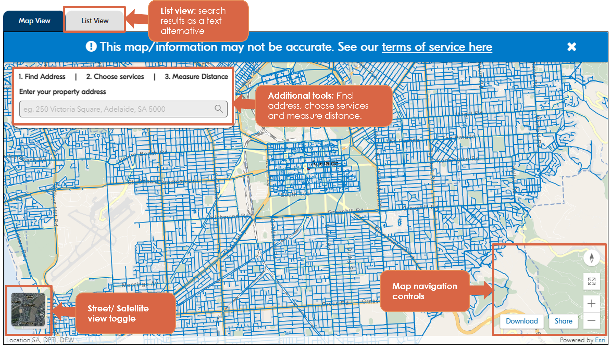
The Connections estimator map is composed of three main areas:
- map: displays an overhead map with coloured lines displaying an indicative availability of water, recycled water, sewerage and fire connections including the approximate location of water meters.
- map navigation controls: use the controls to zoom in and out, toggle between street map or satellite views, reset the map orientation, enter a full screen view, share your map results or download a copy of your map view.
- additional tools: extra tools to explore the map include;
- Find address: address search field
- Choose services: list of connection services to select including a legend to explain what type of pipe the coloured lines refer to
- Measure distance: a measuring tool to measure distance
- List View: a list view of your search results if you are having trouble reading the map.
You can reveal or hide additional information by clicking on the arrow at the bottom of the pane.
Using the map
The map helps you to find the approximate location of our water, wastewater, recycled water, and fire service mains and water meter points.
The map begins as a view over Adelaide CBD and by default, the map will only display locations of water mains and meter points. To display sewerage, recycled water, and fire service pipes, use the ‘Choose services’ tab on the top left of the map and select the services you would like to display.
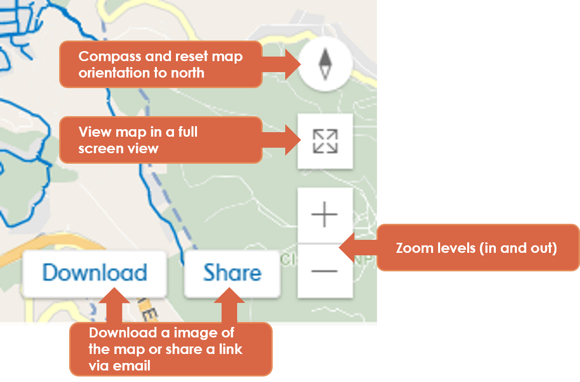
- Compass: The compass points due north. Clicking it will reset the map orientation back to due north.
- Zoom: Zoom in and out.
- Full Screen: Increase the size of the map to a full screen view. To exit from this view, click the button again “Exit fullscreen’ or press ‘esc’ key on your keyboard.
- Download: The download button captures a screen shot of your map view. This can be saved as a jpg file.
- Share: The share button generates an email enabling you to share your map search result via an email link.
Navigation:
When using a computer, move around the map by clicking and dragging with your mouse or touchpad. You can also zoom using the scroll wheel on your mouse or the scroll function on your touchpad.
If you are using a mobile device, move around the map by touching and dragging. You can also zoom by using two fingers in a pinching gesture.
Search for an address
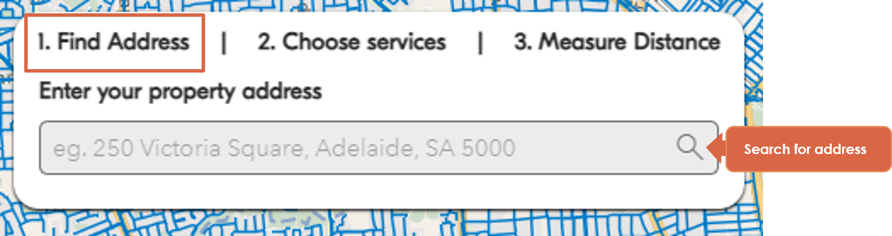
The search field uses a predictive address finder and will attempt to provide address options for you to select as you type.
Click the magnifying glass icon or press ‘enter’ to execute your search.
The map will locate your address and drop a red location pin at the destination.
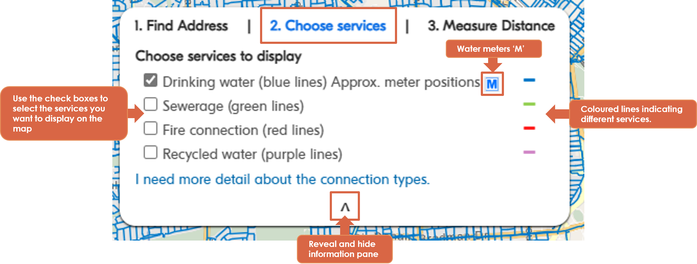
Choosing which services the map displays
By default, the map will display the approximate location of drinking water mains and their associated meter connection.
Using the "Choose services" option, you can also view sewerage, fire services, and recycled water mains by selecting or deselecting the checkboxes next to each service.
Each type of connection service is represented by a different coloured line.
- Drinking water – blue line
- Sewerage – green line
- Recycled water – purple line
- Fire Service – red line
- Drinking water meter points are represented with a blue ‘M’

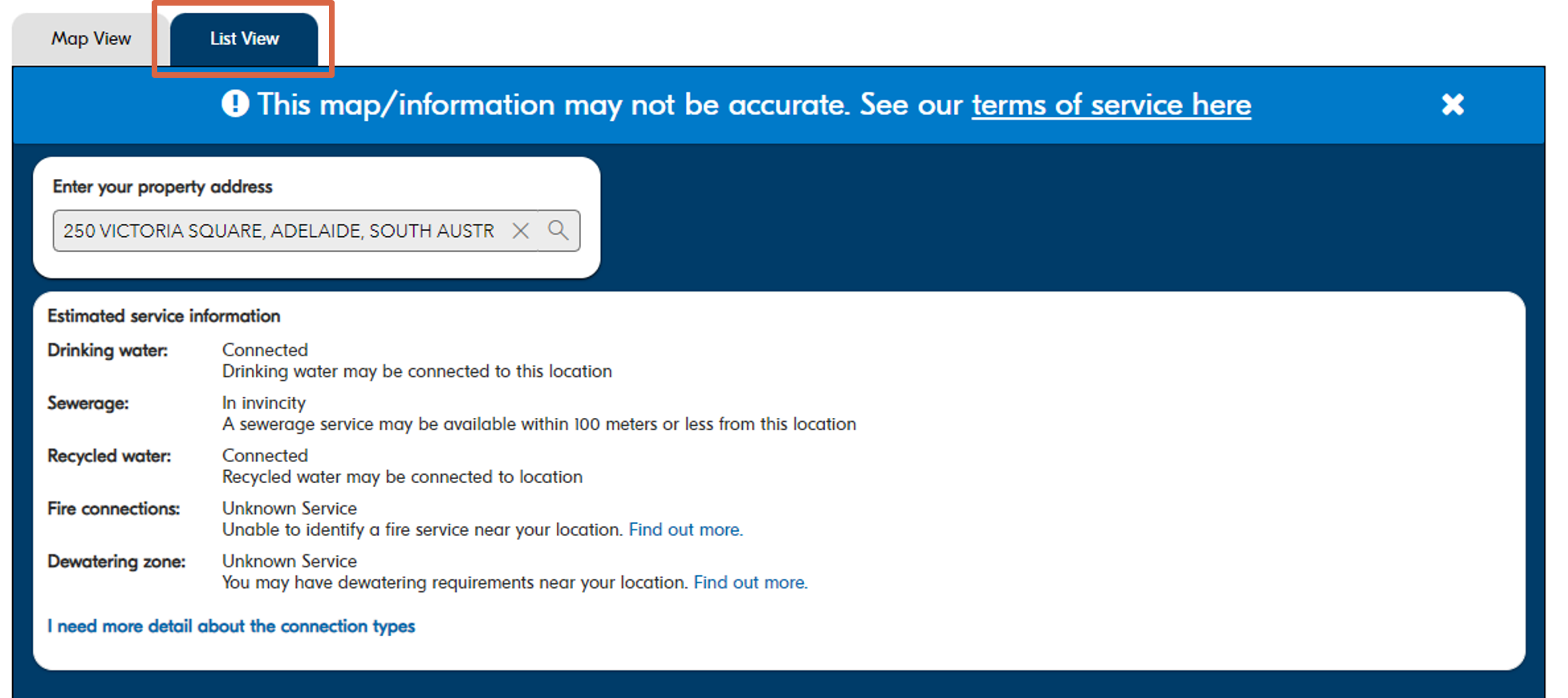
List view
The map’s “List view” provides users with a text alternative for their map results.
Clicking on the “List view” tab will let you know if a service may be
- Connected to the location you searched.
- In the vicinity of the location you searched.
- Unable to be identified for the location you searched.
You can toggle back to the map view by clicking on the “Map view” tab.
Measure distance
The “Measure distance” option enables you to measure the distance between two points on the map or the area of a property.
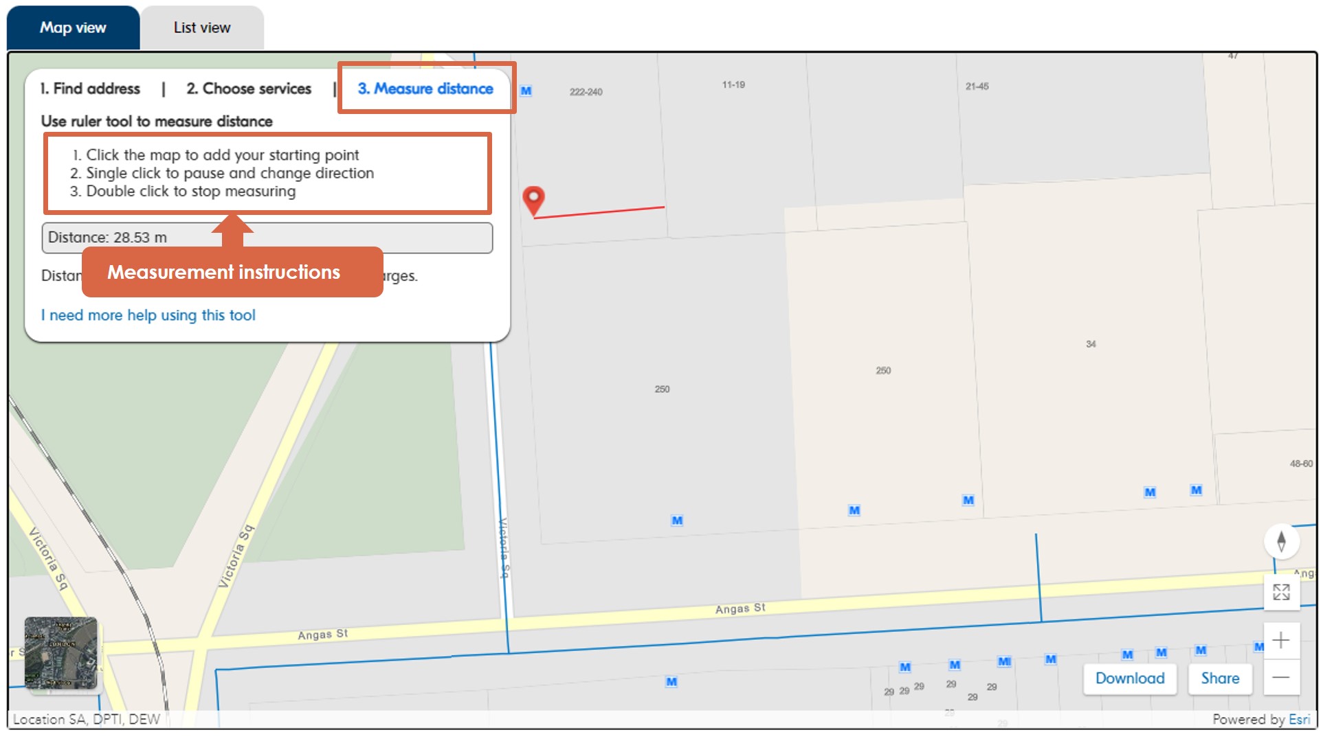
Measure the distance between two points
To measure the distance between two points, select the “Measure distance” tool and click on the map where you want to start your measurement; this will drop a red pin at your starting point.
Move the measuring tool to the end point of your measurement (a red line will show you where you are measuring). To stop measuring, double click/tap. This will drop the final pin and complete the measurement.
The distance you are measuring is recorded on the left in the Measure distance pane.
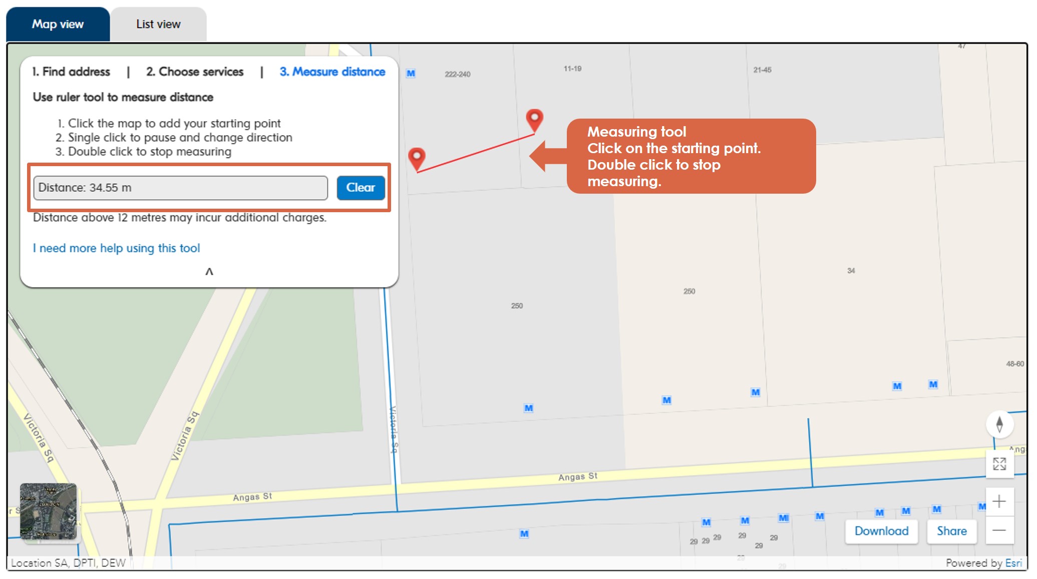
You can continue your measurement and measure around corners by clicking once and continuing to measure from the second point.
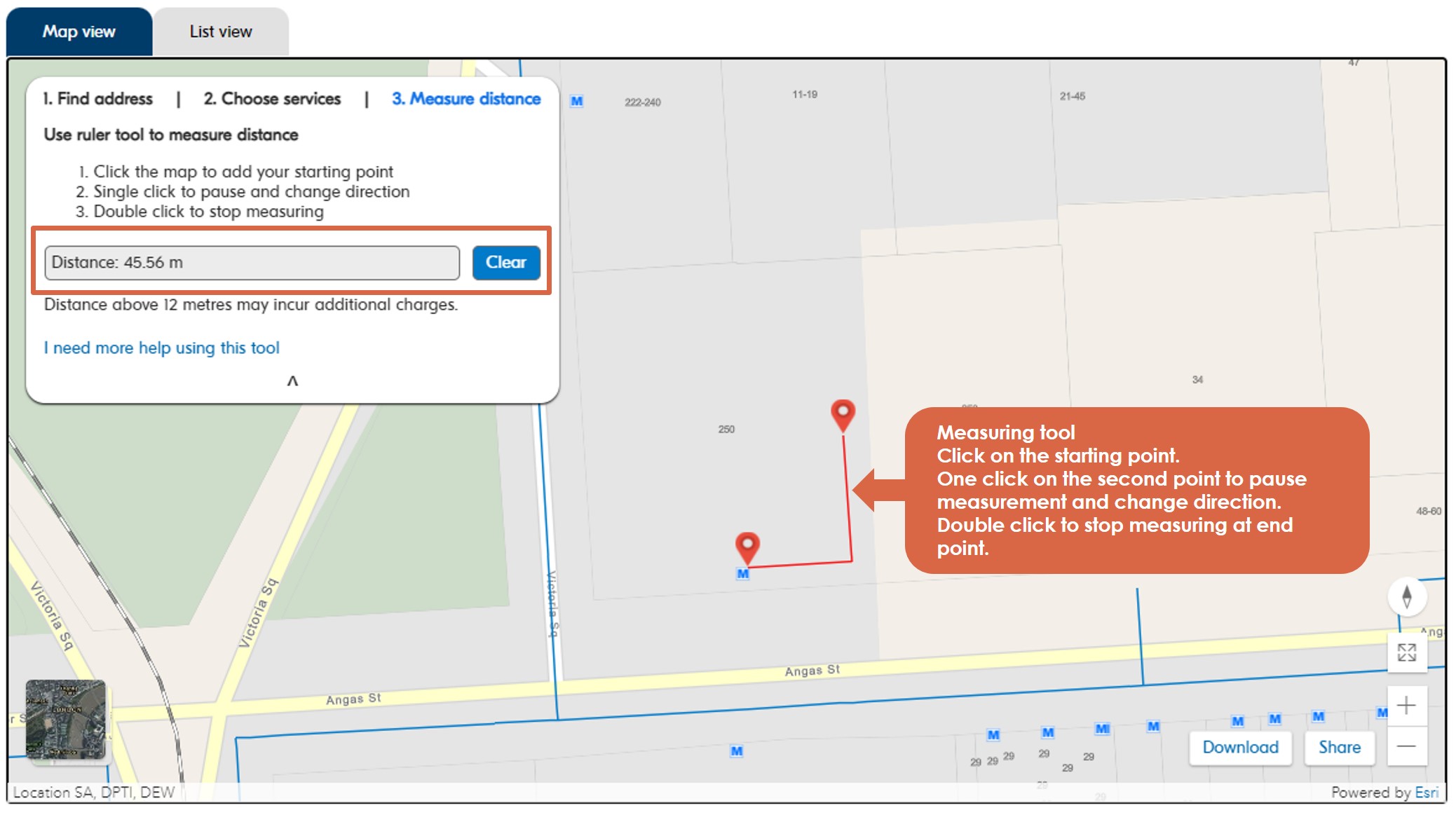
Click 'clear' to reset the measurement and measure a new distance.
Further support
For help using our map, contact our Customer Care Centre.
For more information about connecting to our services, please contact connections@sawater.com.au.