


To prepare for your visit, please check the conditions of access.
A number of access points into the reserve by foot or vehicle are available, which are clearly shown on the maps below and at entrance gates.
 Fishing
With a fishing permit, you can fish from the shoreline, or on the water from a canoe or kayak.
To protect water quality by ensuring the reservoir remains uncontaminated, burleys and fish attractants are not permitted. Collection containers for fishing waste (such as lines, hooks and sinkers) will be available for environmentally safe disposal of these items.
If you happen to catch Carp or Redfin, they must be taken home for cleaning and consumption as they cannot be returned to the water. Murray Cod are strictly catch and release only, and must be gently unhooked while in the water and released immediately.
 Walking and running
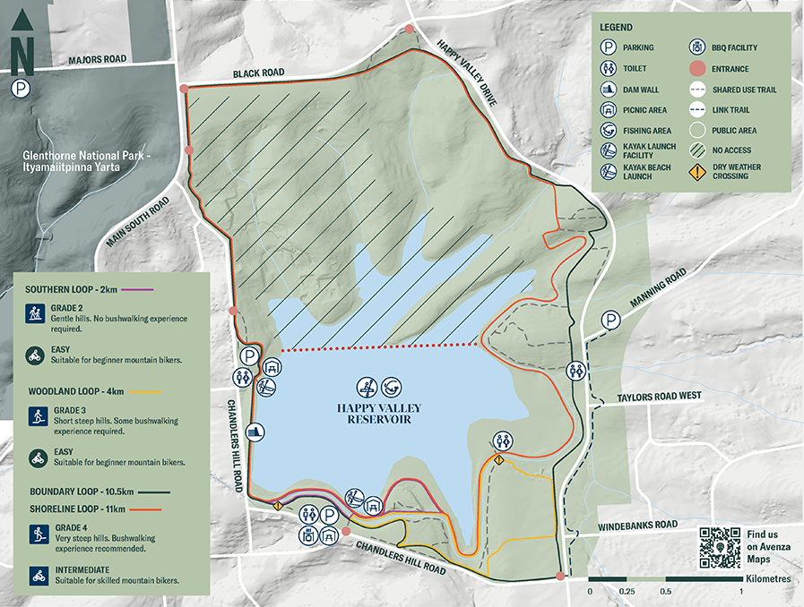
Trails range from two to 11 kilometres in length with varying intensity – Grade 2 with gentle hills to Grade 4 with very steep hills.
The reserve’s longest trail, the 11 kilometre Shoreline Loop, takes you along the water’s edge, through a pine forest, native flora and open grassy areas. If you’re looking for something a little more vigorous, you can take the trail link to Glenthorne National Park – Ityamaiitpinna Yarta, making the combined area more than 1,500 hectares.
Southern Loop: 2 km | 25 minutes (Grade 2, gentle hills)
Woodland Loop: 4 km | 50 minutes (Grade 3, short steep hills)
Boundary Loop: 10.5 km | 2 hours (Grade 4, very steep hills)
Shoreline Loop: 11 km | 2 hours 30 minutes (Grade 4, very steep hills)
Times indicated are for walking. Or you can put on your runners and enjoy it all at a faster pace!
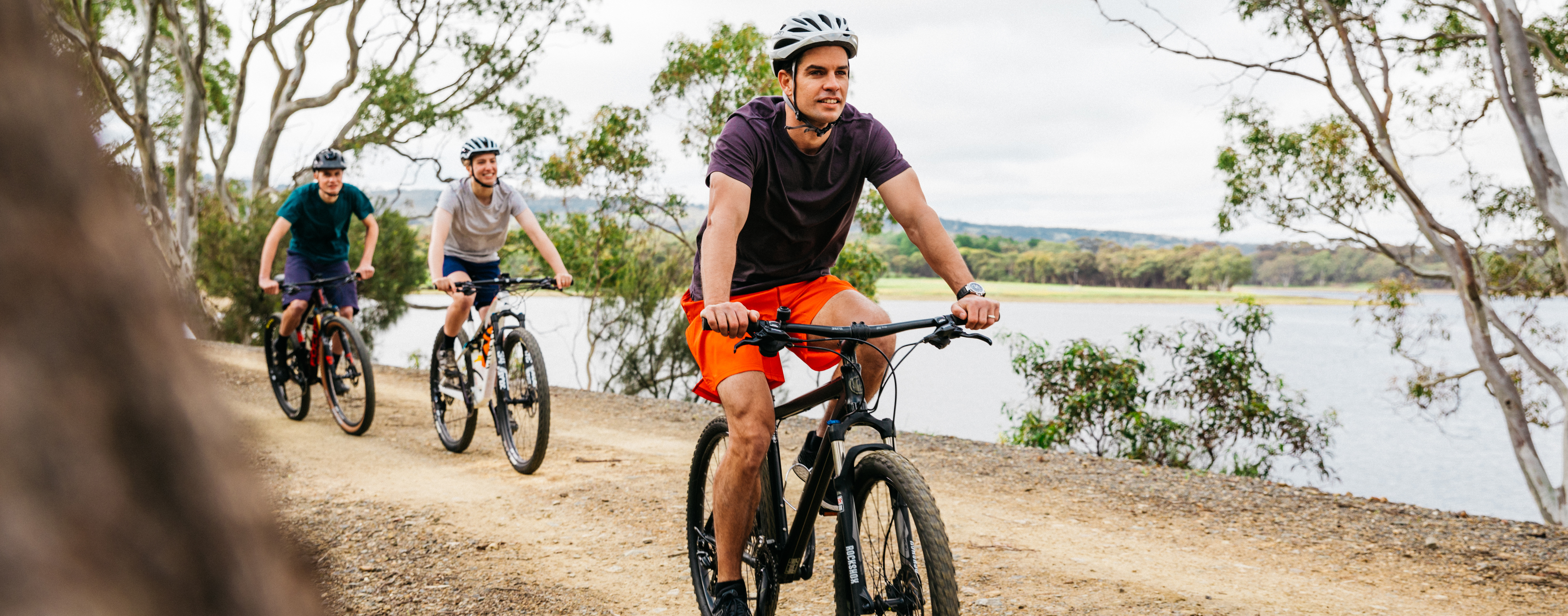
 Cycling
All paths at Happy Valley are suitable for mountain bikes – and it’s a great way to experience the reserve. These paths are shared with pedestrians, so please be considerate of other trail users.
Southern Loop: 2 km | 10 minutes (easy, suitable for beginners)
Woodland Loop: 4 km | 15 minutes (easy, suitable for beginners)
Boundary Loop: 10.5 km | 40 minutes (intermediate, suitable for skilled mountain bikers)
Shoreline Loop: 11 km | 45 minutes (intermediate, suitable for skilled mountain bikers)
 Kayaking/Canoeing
You can choose your own experience with a kayak or canoe, from a short meander to a full day's kayaking adventure exploring the more than 110 hectares of water and shoreline. There is a launch pontoon and a shoreline beach launch area to help get you on the water – no matter what the water level. There is an all-accessibility kayak facility located at the Tower Entrance. Accessible parking is nearby and kayaks can be dropped off directly in front of the kayak launch before parking your vehicle. Please note, there is no storage for wheelchairs on or near the launch facility.
Kayaks and canoes (including inflatable kayaks which comply with ISO-6185 and carry the appropriate badge) are the only type of watercraft permitted on our reservoirs. Motorised craft, dinghies, row and sailing boats are also not permitted, along with electric or fuel-powered motors and sails fitted to canoes and kayaks. If you are planning on kayaking at Happy Valley, please ensure you wear an approved lifejacket.
 Picnicking
Happy Valley Reservoir Reserve is the perfect place to stop and enjoy a picnic with friends or family. There are two open space picnic areas with barbecues and shelters, or you can pack a picnic basket, blanket and chairs and discover your own private spot to sit back, relax and enjoy this uniquely beautiful place.
 Dam wall and lookout
The dam wall offers spectacular views of the reservoir, the reserve, and beyond up to the Adelaide Hills.
 Wildlife and birdwatching
The Happy Valley Reservoir Reserve is made up of around 600 hectares of natural refuge where wildlife, including kangaroos and other native species, can move freely between the reserve and surrounding areas. It is also home to more than 90 species of land and water birds. Please keep your distance from wildlife: do not feed, disturb, or remove native flora and fauna.
SA Water will monitor the wildlife to ensure Happy Valley remains a safe and enjoyable place to visit, while protecting the animals that call it home.
 Immersive technology
Let your smartphone or tablet take you to another dimension with augmented reality. The Explore Water app interacts with augmented reality frames at the southern end of Happy Valley Reservoir Reserve, turning the natural environment into a digital playground.
The 9 kilometre geocaching trail takes you on a GPS-driven treasure hunt through the reserve. Use your GPS-enabled device with QR code scanner to find the 12 stops. The trail is suitable for children aged six and older and can be walked or cycled as a group or by solo adventurers.
 Car parking and entry points
There are two car parks suitable for cars and trailers, as well as accessible parking for people with a disability permit. One can be accessed on the western side near Berkeley Road, and the other from the southern side, off the roundabout connecting Kenihans Road to Chandlers Hill Road.
In addition, there's a number of pedestrian entries strategically placed around the perimeter, which enable people living in the surrounding suburbs access into the trail network.
Dogs are not permitted at South Australia’s reservoir reserves, regardless of whether they are on a leash, as they can carry harmful bacteria and viruses that can easily contaminate the water and are a risk to the safety of the drinking water. Dogs also pose a threat to local native birds and wildlife. Assistance animals are excepted.
Fox baiting also occurs in our reservoir reserves and can be lethal to dogs if ingested.
Blue-green algae, which naturally occurs in our reservoirs, is also highly toxic to dogs if they drink it.
Dog owners are encouraged to make use of dedicated dog parks in their local area.
Click the map below for a print friendly version.
Maps on your mobile
If you have a smartphone or tablet you can download the free Avenza Map app and have interactive reservoir reserve maps on hand when you need them.
The app uses your device’s built-in GPS to plot your real-time location within the reserve onto a map. The app can be used without a network connection and without roaming charges. You can also measure area and distance, plot photos and drop placemark pins.
How to get it working on your device:
1. Download the Avenza Maps app from the app store (iOS/Android) whilst you are still in range (its free!).
2. Open up the app and click the shopping cart icon.
3. Click ‘Find’ and type the name of the reservoir reserve you are looking for.
4. Click on the map you are after and install it (all our maps are free).
5. You will now find a list of your installed maps on the home page of the Avenza Maps app.
6. Use our maps through the Avenza Mapa app while in the reserve and never take a wrong turn again.